Last week, the day before we left on vacation, I spoke with a coworker who was on vacation up in Western Washington State. She complained that it had rained her entire vacation- the first real rainy week during an otherwise abnormally sunny Puget Sound Summer.  I made an appropriate sympathetic response, but didn’t really give it much thought. I should have. When we arrived in Whitefish 2 days later, the same front reached us. For 72 hours, the mercury never cracked 55F, and our hikes and explorations each day were at least partly in the rain. We made the best of it, but a number of activities we’d planned- such as swimming in Whitefish Lake- were off the table. We’ll come back to this topic- rain- in a moment.
Quick Glacier NP Geology
 Anybody who knows anything about Glacier National Park knows that one of the things that make it super-cool is its outstanding mountain scenery, which of course is a result of its awesome geology and repeated glaciations. The mountains of Glacier NP are formed as a results of a geological action called the Lewis Overthrust, in which, due to the collision of 2 tectonic plates over the past 170 million years, a huge chunk of rock- hundreds of miles long and a couple of miles thick- has been pushed 50 miles to the East up and over underlying, newer layers of rock. This means that the rocks that compose the Lewis and Livingstone Ranges- the 2 principal ranges of Glacier NP- are nearly 1.5 billion years older than the rocks underneath them!
 That would be cool enough in itself, but over the last couple million years, they’ve been buried, scoured, eroded and carved repeatedly by ice sheets up to a mile thick, resulting in the fantastic scenery today. Everywhere you go in Glacier, you’re smacked in the face with this rich geological/glacial history: Cirques, moraines, arêtes and U-shaped valleys that drain out into spectacular cascading waterfalls.
Tangent: 2 weeks ago Clean Colin visited Glacier. Before we left I asked him on a scale of 1-10 how spectacular the scenery was. For reference I asked him to assume that the Wasatch was a “4”, and Banff was a “10”. He said “8 or 9”. He was dead on. The place is absolutely stunning.
Some Stuff About Glaciers
Side Note: I considered doing a post on glaciers in the park. I don’t think I’ll be able to fit it in, but here are some interesting highlights. There are 26 glaciers in the park, all rapidly receding. In 1850- when the glaciers were first mapped- there were at least 150 glaciers. By 2030, there are expected to be 0.
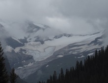 Obviously this is both disappointing from a scenery standpoint and disturbing as an indicator of climate change. But the numbers, dramatic as they are, are perhaps just a titch misleading in the bigger picture. 1850 was roughly coincident with the end of the Little Ice Age, a period of global cooling from about 1500AD to 1850 which saw the freezing over of the Baltic Sea (many times), New York Harbor (at least once) and the River Thames (many times.) During this time the glaciers in the park expanded, and so in 1850 were more numerous and extensive than they probably were say around 1000AD or so*. Still, the rapid disappearance of the glaciers occurring now is both sad and alarming.
*Do not misinterpret this factoid as either doubt of, or evidence against, human-influenced climate change; the evidence that human activities are lending to global warming is simply overwhelming.
Back To The Point Already
Yeah so anyway, my point is that pretty much everybody knows Glacier’s geology is way, way cool. But what most people don’t know is that Glacier’s forests are way, way cool, and that together with the surrounding forests in Northern Idaho, Southern BC and Southern Alberta, are arguably the most complex, fascinating and diverse forests found anywhere in the Rockies*.
*I recognize I’m setting myself up here just a bit. If one considers the mountainous spines of Central Mexico to be southern extensions of the Rockies, my hyperbole doesn’t quite hold up.
I mentioned in the last post that as we moved North into Montana, the Larches we encountered are sort of an outlier of the Boreal Forest to the North.  In some sense this is part of a broader pattern, which I touched upon back in February, when we looked at Lodgepole Pine at its Southernmost extent in the Rockies, the Uintas. Another example would be Paper Birch, Betula papyrifera, (terrible photo, left. For some reason this is the only Birch photo I bothered to take- sorry) a common tree where I grew up in New England. Paper Birch is also a common tree of the Boreal Forest, extending from Maine to the Yukon (almost the same range as Tamarack.) When we arrived in Whitefish, there it was, all over the place at its Southernmost reach in the West.
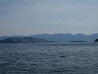 Hydrology Tangent: The highlight of our drive North from Missoula to Whitefish though wasn’t trees- it was stunning Flathead Lake (pic right). 28 miles long, it’s the biggest natural freshwater lake in the lower 48 West of the Mississippi. The setting is lovely, and the coastline is, if anything, more interesting than Lake Tahoe, with numerous bays, inlets and islands.
Nested Hydrology Tangent: Cool as Flathead Lake is, it’s only a small remnant of an even cooler, way huge prehistoric lake: Lake Missoula. Lake Missoula existed between 19,000 and 13,000 years ago and covered up to an astounding 3,000 square miles. Now you may be thinking, “Yeah, yeah, this sounds like that Lake Bonneville story you’re always going on about…” But Lake Missoula was even cooler, for 2 reasons. First, it was a pro-glacial lake, located at the edge of the melting ice sheet. So while the southern shores were dry land, the Northern shore was the massive Cordilleran ice sheet. The lake must have been spectacular, with ice bergs calving off regularly.
 But even cooler still, Lake Missoula was separated from adjacent pro-glacial Lake Columbia by a 2,000 foot-high wall of ice on its Western edge- a Southward extension of the ice sheet. And roughly 40 times over the life of the lake*, the ice dam gave way, leading to spectacular repeated floods which created the Channeled Scablands of Eastern Washington and actually carried icebergs as far as the Willamette Valley in Oregon.
*Though the earlier floods were much bigger and more destructive than the later, smaller floods.
Again, Back To The Point
This mix of Boreal and Rocky Mountain Forests would interesting enough on its own, but what really makes the forests of Northwest Montana fascinating is another influence- the same influence that screwed up our vacation weather- the Pacific Northwest.
 Unlike the Rockies in Utah and Colorado, the Rockies up in Western Montana, Northern Idaho, and Southern British Columbia and Alberta receive their precipitation via storm tracks from the Pacific Northwest. And this differing precipitation pattern- and schedule- results in a very different forest- the Columbian Forest.
The Columbian Forest isn’t so much a single forest type as it is a mosaic of types. Northwest storm tracks and rugged mountainous terrain conspire to create forest pockets more like the West slope of the Cascades than the Wasatch. Montana trees include a whole host of Northwest characters absent from Utah and Colorado, including Western Hemlock, Western White Pine, Grand Fir, Western Red Cedar and of course Western Larch, which despite its close kinship to Tamarack, is really a species of the Pacific Northwest, not of the Boreal Forest.
 These “Northwest pockets” are almost* always on the West slope of mountain ranges; East Slope forests are generally drier, and more closely resemble those of the Rockies further South.
*Guidebooks tell you that you won’t find the Pac-Northwest-type trees East of the Continental Divide. I found 1 Western Hemlock and a stand of about 1/2 dozen small Western Red Cedars along the trail to St. Mary Falls, on the North Shore of St. Mary Lake (Atlantic side.) But in general, the guidebooks are right.
Our first day in Glacier National Park, we hiked up along Avalanche Creek to Avalanche Lake. The Avalanche Creek drainage lies on the West Slope of the Livingstone Range, along the South side of Lake McDonald, where Pac-Northwest forest types are most pronounced in the park.
 The 2 overwhelmingly dominant trees along the Avalanche Lake trail are Western Hemlock (pic right = trees, pic left = cones, needles) and Western Red Cedar. We’ve seen Eastern Hemlock both last summer, and again last week, in Maine, and we saw Mountain Hemlock last summer as well, during our family vacation to Lake Tahoe. But we’ve actually seen Western Hemlock as well, way back when, before anybody ever read this blog.
  We saw it- of all places- in Mendocino, during Awesome Wife’s & my 10th anniversary trip early last summer. That’s right- the last time we saw this tree, it was in the fog-bound, temperate forests of the Northern California coast. And yet here it was again, the exact same species, in far higher densities, in the high mountains of Montana.
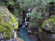 Tangent: The Avalanche trail is wonderful. It leads past stunning falls (pic right) to a beautiful lake (pic below, left), is not very difficult or long, and is very kid-friendly. For these reasons it is one of the most popular trails in the park. My advice: go early. We started hiking up around 9:30AM and had the trail to ourselves most of the way up. But when we came down around 12:30 or so, there was practically a continual stream of hikers coming up.
 Nested Tangent: At least 1 out of every 3 of whom asked me, “Is it much farther?” or “How much farther?” What I hate about this question is that if you don’t give then the answer they want- that it’s right around the corner- they often give you a disgusted scowl. I want to say, “Hey, I didn’t make the trail, you asked me a question and I answered it- don’t get all pissy with me for answering your damn question…” But of course I never do…
This is perhaps why in real life it would probably suck to be a ranger. When you think about being a ranger, you think of long solitary walkabouts in the backcountry, sleeping under the stars, communing with nature and maybe even adopting a bear cub or something. But I suspect that what it mostly entails is answering the same questions over and over again from scowling tourists.
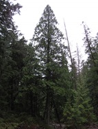 Western Red Cedar, Thuja plicata (pic left = tree, below & right = leaves/scales), we haven’t looked at before, and its presence here seems even more remarkable. WRC is a tree of the coastal Northwest forests, occurring from around Eureka, CA up to the Queen Charlotte Islands. The only place it occurs East of the Cascades is here in the Columbian Forest. WRC is also fascinating in that it’s not a member of Pinaceae, the Pine Family, but instead belongs to Cupressaceae, the Cypress family, and so is related to things like Juniper* and Giant Sequoia and Incense Cedar, trees with which it shares its trait of scale-like (not needle-like) leaves.
Side Note: In fact, the presence of WRC in Montana forests reminded me of Incense Cedar around Lake Tahoe- a lone Cypress Family tree popping up in a forest of PLTs. But unlike Incense Cedar in the Sierra, which usually appears alone at widely–spaced intervals, WRC often forms sizeable stands.
*Actually Common Juniper, as well as Juniper seedlings of all species(?), has needle-like leaves. But almost any Juniper you see around Utah has scale-like leaves.
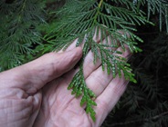 Right from the trailhead, the hike felt like a trail in Washington or Oregon, or even Maine (with the dense Hemlock stands), and I had to keep reminding myself of where we were. It wasn’t just trees; the understory was straight out of the Pac-Northwest as well. One of the most common small trees/large shrubs in the Lake McDonald Cedar-Hemlock forest is- amazingly- Pacific Yew, Taxus brevifolia (pic below, left).
Yews Are Way Cool
 I haven’t mentioned Yews before, probably because they don’t occur near any of the places I’ve visited in this blog (with the exception of Mendocino.) Yews are part of a whole other family of conifers- Taxaceae- that we haven’t even touched, and which parted ways with Cupressaceae roughly 200 million years ago. Of the handful of Yew species in North America, Pacific Yew is the only one with a significant range, overlapping for the most part with WRC along the Northwest Pacific coast. Yews have flattened needles growing along the twig in 2 opposite, very even (more so than hemlock) rows (pic below, right). Pacific Yew is usually a large multi-stemmed shrub, but under the right conditions can grow as high as 50’.
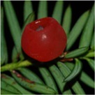
 There are (at least) 2 cool things about Yews. First is their “berries”, which aren’t really berries or even fruit, but a fleshy structure formed by the growth of a specialized scale (leaf) called an aril, which encloses the seed. These aril-“berries” (pic below left, not mine) are eaten by birds who then pass and disperse the seeds. If this story sounds familiar it should, because it’s basically another instance of the Juniper-berry-parallel-evolution-of-fruit-story I told back in January. Yew is yet another, parallel, independent evolution of “fruit” by a conifer.
 The second cool thing is taxol, or paclitaxel, a compound (C47H51NO14) (chem diagram, right) which occurs in the bark of Pacific Yew. Taxol is a mitotic inhibitor, which means that it inhibits mitosis, the process by which a single cell divides to become 2.
  Inhibiting mitosis is extremely desirable when fighting cancer, and so is used in some chemotherapy treatments. Independent evolution of fruit, fighting cancer- Yews are way cool. BTW, the berries are not edible for humans.
Side Note: Taxol is now synthesized, and is no longer obtained from T. brevifolia.
 The Pac-Northwest effect extends clear down to the ground. The most common knee-to-waist-high shrub in the Avalanche Creek forest is this guy, Devil’s Club, Oplopanax horridus (pic right). The broad leaves reminded me of Thimbleberry back home, but any similarity ends there. The stems are covered with spines and the berries are poisonous. O. horridus* is another plant of the Pac-Northwest that shows up here in the Columbian Forest**.
*Is that a great name or what?
**It also shows up in parts of Ontario and on Isle Royale in Lake Superior- how weird is that?
 Beyond the vascular plants, the forest is practically carpeted in lush mosses (pic left). And then the lichens- tons of foliose and fruticose lichens (pic below, right) all over the place, such as we rarely see in the Wasatch.
 Over the next couple of days I ran into other bits and pieces of this Cedar-Hemlock forest type on various bike rides, hikes and drives around the Flathead Valley. One easy-to-see example is the forest lining the road up to Big Mountain Ski Resort, mostly WRC and Hemlock up to the ~4,000 foot level.
  Another is along the lower reaches of the “Ewok Village” trail (pic left), part of the Desert Mountain mtn bike ride. It’s not really predictable, and the various patches of Pac-Northwesty forest aren’t all the same; some are full-on Cedar-Hemlock-Yew, while others are just standard Douglas Fir or Lodgepole Pine forests with an unexpected stand of WRCs suddenly popping up.
 Botany-Tangent/Spotlight: That same “Ewok Village” Trail, is the only place around Glacier I saw Western White Pine. There’s a bunch lower down on the trail, just below the Cedar-Hemlock area. You’ll know it by the big (6”-9”) cones in the trail (pic right). To find the trail, buy the local mtb guide at Glacier Cyclery and check out the “Desert Mountain” ride. I did it as an out & back instead of a loop, which I recommend, but talk to someone at the shop (or me) before trying to access it out & back on your own.
The cool thing about the Columbian forest is the mosaic of forest types and relative explosion of diversity it represents. It’s a wonderful and unexpected violation of the rule that numbers of species diminish in the Intermountain West as you go farther North.
 On a more personal level, the entire Cedar-Hemlock forest just feels like part of another world- someplace completely different, that does not belong there- somehow magically dropped into the middle of the Rockies. It’s almost as if you were walking across a prairie in Kansas, and all of a sudden you came upon a chunk of Costa Rican rain forest. It’s just totally counterintuitive.
In addition to the many trees and shrubs we came across that you’d never see in Utah, we encountered a whole panoply of new wildflowers. But they deserve a post of their own.
Next Up: The One Thing To Take To Glacier NP Is A Flower Guide


